Day1: Taroko Tribe Culture
Taroko National Park Visitor Center
The Taroko National Park has an area of 92,000 acres, it's a mountain-type national park surrounded by the mountains on three sides and next to the Pacific Ocean; Liwu River (Liwuxi) is flowing through the park, a connection between the mountain and the ocean. A series of connected mountains, high-altitude mountains, and deep valleys make up its most significant landscapes. 90% of the area is covered by mountains. The northern section of the Central Mountain range connecting with other mountains forms a unique and complete geographical landscape, including peaks of Hehuan Mountain (Hehuanshan), Black Qilai (Qilai Mountain), and, Mt. Zhongyangjian, which is one of the top 3 peaks in Taiwan, as well as Mt. Nanhu. Furthermore, there're other unique terrains, including cirque, valley, cliff, lifted river terrace, and meander core, etc.
Comparing with other mountain-type national parks, Taroko National Park is a more friendly national park. Climbing along the Central Cross-Island Highway, tourists can experience through the changing weather of 4 seasons ranging from subtropical zone to subarctic zone in one day. With the different altitudes, the changes in plant landscapes varying from broad-leaved forest, needle-leaved forest, to alpine tundra. Also, the animals, such as Taiwan Blue Magpie, Formosan Macaque, enrich the appearances of the ecological environment in the area.
Buluowan
Buluowan is a double layered river steppe, with Mt. Da standing on its south, and Liwu River flowing on its north. It has abundant natural biological resources, which include varieties of tropical monsoon rainforest plants, and many animal species. The place is ideal for conducting natural observation activities.
The Buluowan Administration Station in Taroko National Park's Administration Center spent years cultivating the Formosan Wild Lily; now a sea of wild lilies bloom each year, from March to May. The lily fields near the Buluowan Tourist Center are a beautiful sight, which continually amaze and attract visitors.
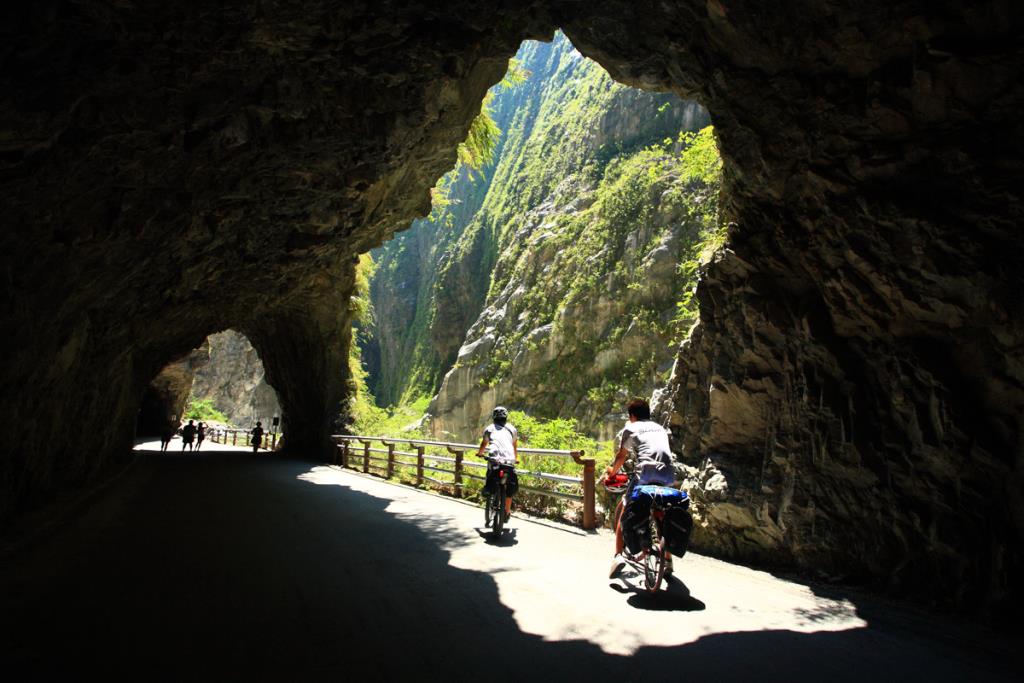
Day2: Zhuilu Historic Trail, Swallow Cave, Tunnel of Nine Turns
Day3: Baiyang Trail, Bilu Sacred Tree, Guanyuan Pine Tree Hiking Trail
Baiyang Trail
Baiyang Trail was originally a construction pathway used by Taiwan Power Company, but today it has been turned into a flat and wide trail that is suitable for a weekend hike. After passing Baiyang Bridge, the Trail would lead the hikers to Baiyang Waterfall, which pours straight down from the cliff afar and meanders down to the lower-level waterfall, bringing forth a magnificent sight. Viewing from the observation deck, visitors would have a clear view looking up to the white silks of waterfall as they cascade down amidst the majestic mountains and present a breathtaking show.
Guanyuan Pine Tree Hiking Trail
Kuan Yun Youth Activity Center
Day4: Hehuan Mountains
Hehuan Mountain North Peak
Mt. Shimen
Shimen Mountain (also called Shimu Mountain), stands at 384m above sea level. The trail is sheltered by the forest. It takes about half hour to walk to the observation deck and about an hour to reach the triangulation station at the summit. The last 200m before the summit is very steep. Visitors almost have to crawl to move forward. Along the way, one can see clearly the views of Shimen Village and the Sichong Creek.
Mt. Hehuanjian (Mt. Hehuan Peak)
Hehuan Mountain used to be the hunting ground for the Atayal people before it became deserted and difficult to get to. After the Wushe-Dayuling Feeder road to the Central Cross-island Highway was completed, the mountain became the most celebrated snow watching spot in Taiwan due to its unique terrain and accessibility. Besides during the snow season, the high-mountain landscape and the cold temperate climate also make it a popular location for sightseeing and staying away from summer heat. Moreover, being a gateway to the Hehuan Peaks and Qilai Mountain Peaks, it has been one of the best places for mountain climbing. The trails in the Hehuanshan National Forest Recreation Area are located on the border between Renai Township in Nantou County and Xiulin Township in Hualien County, the source of the Dajia River, Liwu Creek and Zhuoshui River. After the Wushe Feeder Road to the Central Cross-island Highway was opened, the Hehuan Mountain Peaks became places for people to climb without heavy equipment. The trails mainly include the ones to go up to the Hehuan Main Peak, East Peak, West Peak and North Peak as well as Shimen Mountain and Hehuanjian Mountain.
Day5: Hehuan Mountain East Peak, Little Chilai
Hehuan Mountain East Peak